Continuing the write-up of our vacation along the Central California coast from the last week of February, we started out with Cambria/San Simeon and Hearst Castle, then wrapped up Wednesday night in Pacific Grove. That brings us to…
Day 3: Thursday — Monterey and Carmel
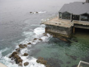
We checked out of our hotel Thursday morning and drove down to the Monterey Bay Aquarium. Then we drove past it, past Cannery Row (which is now a shopping area), up one street, down another, and finally past a bunch of streets with NO LEFT TURN signs trying to find a way into a parking garage. Eventually we ended up on a highway that took us into the main part of town until we could finally turn around and make our way back to the Cannery Row area. *whew*
 So we made it to the aquarium shortly after 10:00, which meant we got to see them feeding the penguins. It was about 15 minutes of introducing the black foot penguins, handing them fish, and asking kids in the audience to be “penguin heroes” by doing things like saving water.
I’d been to the aquarium twice before — once when I was around 10 with my parents, and once when I was around 20 with friends on a road trip, so it seems I’m on a roughly 10-year schedule. I’m 90% certain that half of the current building wasn’t there the first time I went. And I’m not so sure how much was there last time.
 I missed the next two shows, feeding the sea fish and feeding the animals in the kelp forest, due to a tech call from work (the only one all week, thankfully), but Katie caught them both. I got to see a lot of an outdoor terrace on the third floor, which at least had a nice view of the bay, though it was cloudy all morning. Afterward she took me over to the outer-bay tank and showed me the way the anchovies (or was it sardines? neither of us can remember) school together and form this silvery shimmering cloud.
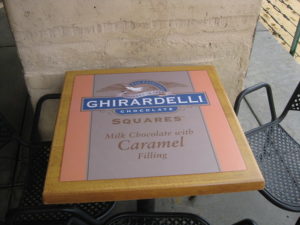
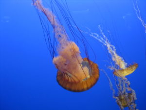
We took in about 3/4 of the aquarium during the rest of the morning and early afternoon, then went looking for lunch in Cannery Row. We ended up at a crepe place near where we parked, which wasn’t terribly good (they used pre-made crepes and some of the fillings that should have been hot were still cold when they were served), then went over to the Ghirardelli shop. Because ever since they closed the shop in South Coast Plaza, I can’t go to a city with a Ghirardelli shop and not go there. (Seriously, that was the way I could handle the stress of shopping in South Coast Plaza.) I had the Mint Bliss sundae. Katie just had the square of chocolate that they put on the sundae. And it was seriously good. Also, check out the picture of one of the tables they had outside.
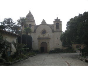 So after stopping for chocolate & ice cream, we made our way out to Carmel By-The-Sea to check out Mission San Carlos Borroméo de Carmelo. Anyone who grew up in California in the last few decades will remember learning about the Spanish colonial period, and the emphasis on the chain of missions founded by Junipero Serra. Both of us had visited a number of the missions on family vacations, but somehow Katie’s family had missed this one, or at the very least she didn’t remember it. So we spent an hour or two exploring the grounds and the museum.
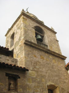 Something I hadn’t remembered was that this mission had collapsed during an earthquake in the 1800s, and was left in ruins until an early 20th century project to rebuild it from surviving structures, drawings and descriptions. Also interesting: it’s an active church, with a school on the grounds (which seemed to let out while we were there). Talk about living history!
Finally we went out to visit my aunt on her ranch up in Carmel Valley. We’d never been there, so it was kind of a surprise to see just how off the beaten path it was. It’s the kind of place where directions involve going to a certain mile marker, then looking for a one-lane road and following it up into the hills.
We only stayed for an hour or so, because we had to be in San Francisco that night, but we got to see the place (which has a fantastic view!) and catch up a bit before getting back on the road.
The next time I plan a trip I’m going to have to remember that driving estimates from Google Maps are not sufficient. Aside from traffic, you need to factor in late starts, stops for sightseeing or bathroom breaks, stopping for lunch, etc. We’d hoped to make it to San Francisco for dinner, but ended up taking the first exit in Gilroy, looking for someplace to eat. Amazingly the street proved to have only a small pizza place and the occasional bar, so we finally turned onto a side street and found ourselves… back at the freeway. Once we pulled out a map, it became clear that the road we’d taken actually paralleled Highway 101 except for the one spot where it turned a little diagonal and crossed. We ended up just eating at Chevy’s, rationalizing that the locations near us had long since closed, so it was still a restaurant we couldn’t go to at home!
It was around 10:30 at night by the time we checked into the Mosser Hotel in San Francisco. We’d picked the hotel based on my brother’s recommendation, and were quite happy with our three-day stay there.
Continued in Friday at WonderCon. More photos on Flickr in my California Coast photo set.